


Center of Innovation on Disability & Rehab Research (CINDRR)


Using GIS to Assess Hurricane Harvey's Impact

Figure 2, Hurricane Harvey Road Closures
As winds from Hurricane Harvey threatened and made landfall in Texas in late August, the VA Office of Emergency Management (OEM) contacted the Planning Systems Support Group (PSSG) for assistance in creating maps of the area. OEM needed geospatial analysis and visual data representation to assess and predict the storm’s path and its potential impact on VA health care facilities and VHA enrollees in the States of Texas, Louisiana, and other areas of the southeastern United States.
To respond quickly to this mission critical endeavor, PSSG collaborated with the GeoSpatial Outcomes Division (GSOD), combining the Geographic Information Systems (GIS) talent in both groups to produce a series of interactive, web-based GIS mapping applications and traditional static maps. The web map application was developed in Portal for ArcGIS, a cloud-based mapping platform available through Esri, a GIS/mapping software development and services company.
Within the Department of Veterans Affairs (VA) Veterans Health Administration (VHA), GIS are used to capture, store, manipulate, analyze, manage, and present spatial or geographic data. GIS plays a pivotal role in supporting health care operations, policy analysis, and strategic planning of the delivery of health care services to our Veterans. The power of GIS and maps offer the ability to make organizational decisions by quickly visualizing data.
PSSG is the leader in the VHA in applying GIS solutions and designing geographic databases, mapping products, and services used in VHA health care analysis. Led by Dr. Nancy Leathers, the PSSG is a field unit under VHA Office of the Assistant Deputy Under Secretary Health (ADUSH) for Policy & Planning (10P1). The GSOD, founded and led by Dr. Diane Cowper Ripley, also applies GIS solutions to support analyses of health care access, particularly for Veterans residing in rural areas of the nation. GSOD is a grant-funded program housed in the Center of Innovation on Disability and Rehabilitation Research (CINDRR) funded by the VA’s Health Services Research & Development (HSR&D) Service and operates under the VHA Office of Rural Health (ORH). It is located in Gainesville, Florida at the North Florida/South Georgia Veterans Health System.
This dynamic web map application was value-added to OEM and featured several spatial map layers of VA information including VA health care site locations and the volume of VHA enrollees per county. Live data from external sources such as FEMA and Red Cross were integrated into the maps and compared with the VA data layers, including 1) rainfall forecasts over a 24-hour period; 2) current roadway traffic status information in areas of the storm’s track; 3) open shelters and their capacities; and 4) various personnel and equipment resources to augment emergency management in affected areas. Together, this collection of visual information in one place, the ability to drill down into specific regions, and access to additional information about features via popups allowed staff at OEM to examine VA assets (enrollees and health care facilities) and visually compare them to available FEMA shelter capacity (Figure 1) and locations of traffic barriers such as road closures (Figure 2).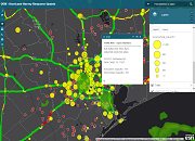
Figure 1, FEMA Shelter Capacity
PSSG and GSOD staff continue to manage and maintain the data behind the web map application. Leadership in the VHA Office of the ADUSH for Policy & Planning (10P1) have recognized and congratulated them for using the power and capabilities of GIS to tell the story behind VA’s emergency management needs assessment in response to Hurricane Harvey. The web map application will also be shared with senior leaders in other VHA Program Offices, including the Deputy Under Secretary for Health (DUSH) for Policy and Services (10P), and up to DUSH for Operations and Management (10N).


